| ||||||||
|---|---|---|---|---|---|---|---|---|
Parcel:
P6 |
| |||||||
| Near: | Luther | 49656 | ||||||
Mix of hardwoods and pine; trees around the outside give privacy on the inside-- pull in and set up camp the same day.
Measures approximately 660 feet East/West, by 660 feet North/South. In my opinion this is the perfect shape for a ten-acre parcel-- square, instead of long and skinny. Think about it-- when you stand in the center of a the typical long ten-acre parcel, it's only 165 feet to the line on either side. With a square parcel, it's 330 feet from the center to every side. It's the same amount of land, but it feels bigger. You'll find many ideal spots to build or set up camp. All the corners are flagged with steel posts, painted bright orange. The corners are not professionally surveyed, but are reasonably accurate. Tips on Finding This LandThis parcel is one of eight ten-acre parcels which together once made up an eighty-acre tract. Currently I do have a sign up for Parcel P1, which is on the paved road. For the parcels in the back, accessed by a private easement, you'll find the little arrow sign pointing down the easement. It's easy to recognize, with a yellow arrow on a brown background. Be sure to print a copy of the Plat. Once you've found the correct location, the aerial photo and dimensions will help you find the corners for each parcel. Please use the Map to the Land link at-left to help find the correct location. Also note you can use the latitude/longitude coordinates with Google Maps on your phone, to lead you to the front of the land. Enter the coordinates separated by a comma, like this: About this LocationLake County has a higher percentage of public lands-- State and National Forest, than any other County in Michigan's lower peninsula. The eastern side of the County (where this land is) is hilly and, in my opinion, the prettiest part of the County. This property is located:
Road AccessA paved County road (Old M-63) runs from Hwy M-131 to the access road to this property. Parcels P1, P2, and P3 are on the paved county road. The other parcels are accessed by a private deeded easement. UtilitiesElectric lines run along the paved County Road (Old M-63). Power has not been run to the back parcels, but a utility easement has been provided in case you ever want to run it back. For water and sewage-- hey, you're out in the countryside. If you want these, you'll have to put in your own well and septic. All this land is high and dry with sandy/loamy soil. You'll have no problem with drainage, and can put a septic tank and drain field anywhere you like.
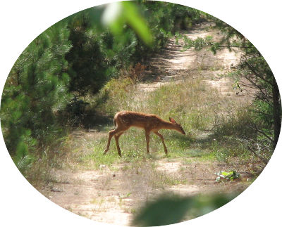
HuntingExcellent hunting. I've seen tons of wildlife on this land. Deer, turkey. There are several water sources nearby, and plenty for them to eat. I got this deer's photo on the access road between Parcels P2 and P3. Local Attractions
If you're looking for a place where the hunting is great, you can leave a camper year 'round, build a cabin or tiny-house, and not have anyone hassle you-- yet you're only a ten minute drive away from a steak dinner and a cold beer-- this is the place. | ||||||||
| Michigan Location: | Township: | Ellsworth | County: | Lake | ||||
| GPS Coordinates: | Latitude: | 44.013086 | Longitude: | -85.609998 | ||||
| Property Tax ID: | part 08-027-002-00 | Yearly Property Taxes: | $ 449.13 | |||||
| Legal Description: | Ellsworth Twp., Lake County, Michigan; T19N-R11W Section 27: NW/4 SW/4 NE/4. Subject to and including an easement for purposes of ingress, egress, and utilities for the benefit of parcels in the W/2 NE/4, extending 33 feet either side of the following described centerline: beginning on the north Section line approximately 530 feet west of the east 1/8th line of Section 27, and running thence southwesterly at about a 45 degree angle, approximately 170 feet, to intersect with the north/south centerline of the W/2 NE/4 of said Section 27; thence southerly along said N/S centerline to a point approximately 760 feet north of the E/W Section centerline, thence in a curve southeasterly to the right along the path of the existing two-track, around the edge of the woods, crossing into the SE/4 SW/4 NE/4, and then immediately into the SE/4 SW/4 NE/4. The intent is to provide access along the existing two-track running southerly through the W/2 NE/4. | |||||||
| Price: | $52,900.00 | |||||||
| Available Terms: | Cash: $500 today, balance within 30 days. Seller will deliver a warranty deed within 10 days of receipt of full payment.
Land Contract (Standard): $5,290.00 down, $578.75 per month, for 15 years. Payment includes property taxes. Interest rate is 11% simple interest; no penalty for early payoff. 90 days same as cash. That means you can buy on land contract, and if you pay off the full balance within 90 days, you pay zero interest. Land Contract (Low Down Payment): $2,645.00 down, $812.52 per month for the first year, after which time your monthly payment drops to $578.75. Payments include property taxes. Interest rate is 11% simple interest; no penalty for early payoff. Term is 15 years; 90 days same as cash. Pay just $500 today to secure sale with any of the above options. Payment options available:
| |||||||
[How to Buy this Land] | ||||||||